Project Description
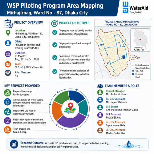
The project titled “Providing Consultancy Services for Digitization Mapping Data for WSP Piloting Program Area, Mirhajirbag, Ward No. 87, Dhaka City” was implemented for the Population Services and Training Center (PSTC) with funding support from WaterAid Bangladesh. The assignment was conducted over a period of three months from August 2011 to October 2011 in Mirhajirbag, Dhaka City. The main objective of the project was to develop detailed GIS-based mapping and spatial databases for the WSP piloting program area to support effective planning, monitoring, and management of the water supply network. The consultancy services included preparation of project boundary maps, physical feature mapping, and development of an updated GIS database. Detailed field surveys were carried out on the water supply network along with household-level data collection. Base maps were prepared to assist surveyors during field operations, and extensive field verification was conducted to ensure maximum data accuracy and authenticity. The project team also prepared final GIS maps of the water supply network for monitoring, evaluation, and decision-making purposes. Through accurate mapping and database development, the project contributed to improved spatial information management and effective implementation of the WSP program activities in the project area.